- Gombrich, E.H., et al. A. Games: Sixty Years of Design (1990. South Glamorgan, UK: Institute of Higher Education) | ISBN 0-9515777-0-0
Abram Games OBE, RDI (29 July 1914 in Whitechapel, London – 27 August 1996 in London) was a British graphic designer. The style of his work – refined but vigorous compared to the work of contemporaries – has earned him a place in the pantheon of the best of 20th-century graphic designers. In acknowledging his power as a propagandist, he claimed, "I wind the spring and the public, in looking at the poster, will have that spring released in its mind." Because of the length of his career – over six decades – his work is essentially a record of the era's social history. Some of Britain's most iconic images include those by Games. An example is the "Join the ATS" poster of 1941, nicknamed the "blonde bombshell" recruitment poster. His work is recognised for its "striking colour, bold graphic ideas, and beautifully integrated typography".[1]
Contents
[hide]
[hide]
倫敦傳真-國家的補品 撐出英倫軟實力
五月初,文建會主委盛治仁到歐洲法國和英國訪問,參訪兩國的文化機構和文化創意產業,同時推動台灣軟實力。
盛治仁到英國時,適逢倫敦南岸中心(Southbank Centre)推出慶祝揭幕六十周年的「英國節」(Festival of Britain)系列活動。對於廣大的英國民眾,這個活動,重新喚起了六十年前南岸中心成立時的社會精神與文化靈魂。但我認為,南岸中心的「英國節」,真 正說明了軟實力的持久性和穿透力,無遠弗屆。
時間回到一九五一年五月三日。英王喬治六世和伊莉莎白皇后共同出現在倫敦聖保羅大教堂外,宣達一件特別的事。喬治六世國王告訴聚集在他面前的群眾,「讓我們祈求,藉著上帝恩典,這些「範圍廣大的現代知識」,能把破壞轉為和平,隨著時間流逝,人們可以更快樂。」。
當時,歷經二次大戰後的英國,依然廢虛遍地,物資缺乏,生活困頓。戰爭雖結束,人心社會依然一片沮喪。英王喬治六世佈達中的「範圍廣大的 現代知識」,指的是在倫敦南岸展開的「英國節」活動。這個活動,集聚了英國當代年輕優秀的設計師、建築師和藝術家和創意和構思,希望可以為二戰後頹廢悲觀 的英倫社會,注入樂觀和希望的活力,並藉此向世界宣傳、展示英國的產品、創意和設計實力。
當天晚上,為了這項特殊活動,居住在泰晤士河另一端的英國皇室罕見地跨過滑鐵盧大橋,前往向來被認為是不毛之地的南倫敦,在新建的「皇家 節日廳」,喬治六世親為「英國節」揭開序幕。一名站在人群中的六歲小男孩,不明究理的問道,「這到底是怎麼一回事?大家在搞什麼?」,男孩的父親告訴他, 「這是未來。」。問話的小男孩雷伊戴維斯,後成為英國七○年代著名樂團Kinks團長,他認為,一九五一年倫敦南岸中心的「英國節」,透過當代文化創意和 各式藝文活動,「讓戰後的英倫重生,跟世界重新接軌。」
一九五一年,在倫敦泰晤士河南岸舉行、為期五個月的「英國節」,吸引了一千萬人參與。除了英國本土民眾外,還有許多從歐陸國家慕名而來的觀眾。
五一年的倫敦南岸「英國節」,斥資八百萬英鎊,對戰後經濟拮据的英國,是不可思議的數字。但這個一九四五年,率先出現在倫敦《新聞紀實 報》上的想法,卻出乎意料的獲得英國政府支持。當時的副首相莫瑞森,更把這個思考和提議,形容為「國家的補品」(a tonic for the nation),並在內閣中大力推動這個以軟實力,對內凝聚社會,振奮民心,對外展現英國文化創意的夢想。
如今,位於倫敦泰晤士河畔,與西敏寺國會遙遙相望的南岸中心,早已成為歐洲最大的綜合藝術中心。除了皇家節日廳、英國國家劇院、國家電影院、海沃德畫廊外,其他許多大小藝文活動中心,都聚集在這裡。整個南岸區域,更因而脫離貧窮,徹底振興。
六十年來,南岸中心不只是英國的文化地標,也是世界藝文活動最重要的場地之一。一九五一年和二○一一年,南岸中心「英國節」內容雖然不 同,但相信文化活動是人人可以參與、可以分享,可以聚合社會民心、可以宣展英國當代藝術創作實力的精神和認知卻一樣。英國工黨政府二戰後,推出的這帖「國 家補品」,歷經政黨更迭,逾半世紀來,歷久彌新。
十九世紀英國女詩人柯勒瑞( Mary Coleridge)的短詩「埃及可能跌下來」(Egypt’s might is tumbled down 漏譯: 權勢 might ),優美的描述了這股柔軟力。巨大的帝國會滅亡、輝煌的羅馬會失去皇冠,威尼斯的驕傲最終也只是徒勞,只有夢想,永遠存 在。(clchiangr@yahoo.com)

 The Festival of Britain emblem - the Festival Star - designed by Abram Games, from the cover of the South Bank Exhibition Guide, 1951
The Festival of Britain was a national exhibition which opened in London and around Britain in May 1951. The official opening was on 3 May.[1] The principal exhibition site was on the South Bank Site, London of the River Thames near Waterloo Station. Other exhibitions were held in Poplar, East London (Architecture), Battersea Park (The Festival Gardens), South Kensington (Science) and the Kelvin Hall in Glasgow (Industrial Power) as well as travelling exhibitions that toured Britain by land and sea. Outside London major festivals took place in Cardiff, Stratford-upon-Avon, Bath, Perth, Bournemouth, York, Aldeburgh, Inverness, Cheltenham, Oxford and other centres.[2]
At that time, shortly after the end of World War II, much of London was still in ruins and redevelopment was badly needed. The Festival was an attempt to give Britons a feeling of recovery and progress and to promote better-quality design in the rebuilding of British towns and cities following the war. The Festival also celebrated the centenary of the 1851 Great Exhibition. It was the brainchild of Gerald Barry and the Labour Deputy Leader Herbert Morrison who described it as "a tonic for the nation".
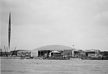
A view of the Festival of Britain from the north bank
Construction of the South Bank site opened up a new public space, including a riverside walkway, where previously there had been warehouses and working-class housing. There was, however, opposition to the project from those who believed that the money (£8 million) would have been better spent on housing. (A film comedy, "The Happy Family", was made about working-class resistance to the demolition that the festival required and featured a London family barricading themselves into their corner shop, 'The House of Lords', to prevent it from being demolished to make way for an access road for the Festival. The shop is finally saved when red-faced Whitehall bureaucrats are forced by public opinion to move the access road. The film starred the biggest comedic stars of British cinema at the time; Stanley Holloway, Kathleen Harrison, Naunton Wayne & Dandy Nichols).
In 1948, the young architect Hugh Casson, 38, was appointed director of architecture for the Festival and he broadmindedly sought to appoint other young architects to design its buildings. He was knighted in 1952 for his efforts in relation to the Festival.
The layout of the South Bank site was intended by the organisers to showcase the principles of urban design that would feature in the post-war rebuilding of London and the creation of the new towns. These included multiple levels of buildings, elevated walkways and avoidance of a street grid. Most of the South Bank buildings were International Modernist in style, little seen in Britain before the war. All except the Royal Festival Hall were later destroyed by the incoming Churchill government in 1953, who thought them too 'socialist' for their taste.[3]
Misha Black, one of the Festival architects, said that the Festival created a wide audience for architectural modernism but that it was common currency among professional architects that the design of the Festival was not innovative. The architects also tried to show by their design and layout of the South Bank Festival what could be achieved by applying modern town planning ideas.[4] A number of buildings on the main South Bank site became iconic of the festival.
Like the adjacent Skylon tower, the dome became an iconic structure for the public and helped popularise modern design and architectural style in a Britain still suffering through post-war austerity. Controversially after the Festival closed, the dome was demolished and its materials sold as scrap. The site was cleared for reuse, and is now the location of the Jubilee Gardens, near the London Eye.* Dome of Discovery, which anticipated the Millennium Dome (designed by Ralph Tubbs)
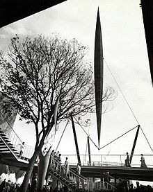
The Skylon tower at the Festival of Britain, 1951
The design of the railway's locomotives, rolling stock and stations were based on his whimsical cartoons in Punch which parodied a pre-Beeching decrepit rural branch line as well the popular myth surrounding such lines. The most famous of the locomotives was Nellie, a copper and mahogany kinetic sculpture who appeared on a charity stamp and a model published by Puffin Books.[11]
In common with the rest of the exhibition it opened on May 3, 1951. Visitors to the live architecture exhibition would first visit the Building Research Pavilion where they were shown problems with housing and their scientific solutions. Then came the Town Planning Pavilion, a large, broadly striped red-and-white tent, which demonstrated the principles of town planning and the urgent need for new towns, including a mock up of an imaginary town called Avoncaster.[12] Visitors then went on to see the buildings which would occupy the site in various stages of construction.
Despite the efforts, attendances were disappointing with only 86,426 people visiting, compared to 8 million who visited the South Bank exhibition.[12] Reaction to the development at the time by industry professionals was lukewarm, with some criticising the small scale of the development,[13] subsequent governments and local authorities concentrated in developing high rise, high density social housing rather than the Lansbury estate model. However the estate continues to the present day and remains popular with residents.[12]
Notable buildings which remain include a church called Trinity Independent Chapel, a public house named The Festive Briton (and now called Callaghans) in a corner of Chrisp Street Market, also part of the estate, with The Festival Inn nearby.
Trowell, a village in Nottinghamshire, was selected from among 1600 others to be the "Festival Village" as a typical example of British rural life. Trowell also has a "Festival Inn".

Stamps commemorating the Festival of Britain - note the Festival icon on the 4d issue
The Festival was also filmed by documentary-maker Humphrey Jennings, as Family Portrait and it is featured in scenes in the feature films Prick Up Your Ears and 84 Charing Cross Road. The upcoming Festival is a central feature in the 1952 comedy film The Happy Family.
The Guide Book to the Festival described its legacy in these words: "It will leave behind not just a record of what we have thought of ourselves in the year 1951 but, in a fair community founded where once there was a slum, in an avenue of trees or in some work of art, a reminder of what we have done to write this single, adventurous year into our national and local history."
The "Festival Style", combining modernism with whimsy and Englishness, influenced architecture, interior design, product design and typography in the 1950s. William Feaver describes the Festival Style as "Braced legs, indoor plants, lily-of-the valley sprays of lightbulbs, aluminium lattices, Costswold-type walling with picture windows, flying staircases, blond wood, the thorn, the spike, the molecule."[18] It was manifested in the New Towns, coffee bars and office blocks of the fifties. (A 1951 office building at 219 Oxford Street, London, incorporated images of the Festival on its facade.) The Festival style was manifested in the design of Coventry Cathedral (1962), by a Festival architect, Basil Spence. Many architects, especially those working for local government, enthusiastically copied its forms and materials but without too much consideration of their durability, resulting in a stock of buildings that have since been much criticized. The design writer Reyner Banham has questioned the originality and the Englishness of the Festival Style and indeed the extent of its influence.[19]
盛治仁到英國時,適逢倫敦南岸中心(Southbank Centre)推出慶祝揭幕六十周年的「英國節」(Festival of Britain)系列活動。對於廣大的英國民眾,這個活動,重新喚起了六十年前南岸中心成立時的社會精神與文化靈魂。但我認為,南岸中心的「英國節」,真 正說明了軟實力的持久性和穿透力,無遠弗屆。
時間回到一九五一年五月三日。英王喬治六世和伊莉莎白皇后共同出現在倫敦聖保羅大教堂外,宣達一件特別的事。喬治六世國王告訴聚集在他面前的群眾,「讓我們祈求,藉著上帝恩典,這些「範圍廣大的現代知識」,能把破壞轉為和平,隨著時間流逝,人們可以更快樂。」。
當時,歷經二次大戰後的英國,依然廢虛遍地,物資缺乏,生活困頓。戰爭雖結束,人心社會依然一片沮喪。英王喬治六世佈達中的「範圍廣大的 現代知識」,指的是在倫敦南岸展開的「英國節」活動。這個活動,集聚了英國當代年輕優秀的設計師、建築師和藝術家和創意和構思,希望可以為二戰後頹廢悲觀 的英倫社會,注入樂觀和希望的活力,並藉此向世界宣傳、展示英國的產品、創意和設計實力。
當天晚上,為了這項特殊活動,居住在泰晤士河另一端的英國皇室罕見地跨過滑鐵盧大橋,前往向來被認為是不毛之地的南倫敦,在新建的「皇家 節日廳」,喬治六世親為「英國節」揭開序幕。一名站在人群中的六歲小男孩,不明究理的問道,「這到底是怎麼一回事?大家在搞什麼?」,男孩的父親告訴他, 「這是未來。」。問話的小男孩雷伊戴維斯,後成為英國七○年代著名樂團Kinks團長,他認為,一九五一年倫敦南岸中心的「英國節」,透過當代文化創意和 各式藝文活動,「讓戰後的英倫重生,跟世界重新接軌。」
一九五一年,在倫敦泰晤士河南岸舉行、為期五個月的「英國節」,吸引了一千萬人參與。除了英國本土民眾外,還有許多從歐陸國家慕名而來的觀眾。
五一年的倫敦南岸「英國節」,斥資八百萬英鎊,對戰後經濟拮据的英國,是不可思議的數字。但這個一九四五年,率先出現在倫敦《新聞紀實 報》上的想法,卻出乎意料的獲得英國政府支持。當時的副首相莫瑞森,更把這個思考和提議,形容為「國家的補品」(a tonic for the nation),並在內閣中大力推動這個以軟實力,對內凝聚社會,振奮民心,對外展現英國文化創意的夢想。
如今,位於倫敦泰晤士河畔,與西敏寺國會遙遙相望的南岸中心,早已成為歐洲最大的綜合藝術中心。除了皇家節日廳、英國國家劇院、國家電影院、海沃德畫廊外,其他許多大小藝文活動中心,都聚集在這裡。整個南岸區域,更因而脫離貧窮,徹底振興。
六十年來,南岸中心不只是英國的文化地標,也是世界藝文活動最重要的場地之一。一九五一年和二○一一年,南岸中心「英國節」內容雖然不 同,但相信文化活動是人人可以參與、可以分享,可以聚合社會民心、可以宣展英國當代藝術創作實力的精神和認知卻一樣。英國工黨政府二戰後,推出的這帖「國 家補品」,歷經政黨更迭,逾半世紀來,歷久彌新。
十九世紀英國女詩人柯勒瑞( Mary Coleridge)的短詩「埃及可能跌下來」(Egypt’s might is tumbled down 漏譯: 權勢 might ),優美的描述了這股柔軟力。巨大的帝國會滅亡、輝煌的羅馬會失去皇冠,威尼斯的驕傲最終也只是徒勞,只有夢想,永遠存 在。(clchiangr@yahoo.com)
From Wikipedia, the free encyclopedia

The Festival of Britain emblem – the Festival Star – designed by Abram Games, from the cover of the South Bank Exhibition Guide, 1951


At that time, shortly after the end of World War II, much of London was still in ruins and redevelopment was badly needed. The Festival was an attempt to give Britons a feeling of recovery and progress and to promote better-quality design in the rebuilding of British towns and cities following the war. The Festival also celebrated the centenary of the 1851 Great Exhibition. It was the brainchild of Gerald Barry and the Labour Deputy Leader Herbert Morrison who described it as "a tonic for the nation".
Contents[hide] |
[edit] The South Bank

In 1948, the young architect Hugh Casson, 38, was appointed director of architecture for the Festival and he broadmindedly sought to appoint other young architects to design its buildings. He was knighted in 1952 for his efforts in relation to the Festival.
The layout of the South Bank site was intended by the organisers to showcase the principles of urban design that would feature in the post-war rebuilding of London and the creation of the new towns. These included multiple levels of buildings, elevated walkways and avoidance of a street grid. Most of the South Bank buildings were International Modernist in style, little seen in Britain before the war. All except the Royal Festival Hall were later destroyed by the incoming Churchill government in 1953, who thought them too 'socialist' for their taste.[3]
[edit] Design and the Festival buildings
The graphic designer for the Festival of Britain was Abram Games who had been Official War Poster artist and whose iconic Britannia symbol of the Festival remains memorable.Misha Black, one of the Festival architects, said that the Festival created a wide audience for architectural modernism but that it was common currency among professional architects that the design of the Festival was not innovative. The architects also tried to show by their design and layout of the South Bank Festival what could be achieved by applying modern town planning ideas.[4] A number of buildings on the main South Bank site became iconic of the festival.
[edit] The Dome of Discovery
Main article: Dome of Discovery
The dome had a diameter of 365 feet and stood 93 feet tall making it at the time the largest dome in the world. It was constructed from concrete and aluminium in a modernist style and housed many of the festival attractions. Internally the dome included a number of galleries on various levels housing exhibitions on the theme of discovery — the Living World, Polar, the Sea, the Earth, the Physical World, the Land, Sky and Outer Space.Like the adjacent Skylon tower, the dome became an iconic structure for the public and helped popularise modern design and architectural style in a Britain still suffering through post-war austerity. Controversially after the Festival closed, the dome was demolished and its materials sold as scrap. The site was cleared for reuse, and is now the location of the Jubilee Gardens, near the London Eye.* Dome of Discovery, which anticipated the Millennium Dome (designed by Ralph Tubbs)
[edit] The Skylon

Main article: Skylon (tower)
An unusual cigar-shaped aluminium-clad steel tower supported by cables, the Skylon was the “Vertical Feature” that was an abiding symbol of the Festival of Britain. It was designed by Hidalgo Moya, Philip Powell and Felix Samuely, and fabricated by Painter Brothers of Hereford, England, on London's South Bank between Westminster Bridge and Hungerford Bridge. The Skylon consisted of a steel latticework frame, pointed at both ends and supported on cables slung between three steel beams. The partially constructed Skylon was rigged vertically, then grew taller in situ.[5] The architects' design was made structurally feasible by the engineer Felix Samuely who, at the time, was a lecturer at the Architectural Association School of Architecture in Bedford Square, Bloomsbury. The base was nearly 15 metres (50 feet) from the ground, with the top nearly 90 metres (300 feet) high. The frame was clad in aluminium louvres lit from within at night. Both the name and form of the Skylon perhaps referred back to the Trylon feature of the 1939 World's Fair. Mrs A G S Fidler, wife of the chief architect of the Crawley Development Corporation, suggested the name and said she derived it from skyhook and nylon.Skylon was scrapped in 1952 on the orders of Winston Churchill, who saw it a symbol of the preceding Labour Government,[6] when the rest of the exhibition was dismantled it was toppled into the Thames and cut into pieces.[edit] Royal Festival Hall
Main article: Royal Festival Hall
Designed by Leslie Martin, Peter Moro and Robert Matthew from the LCC's Architects' Department and built by Holland, Hannen & Cubitts for London County Council. The foundation stone was laid by Clement Attlee, then Prime Minister, in 1949 on the site of the former Lion Brewery, built in 1837.[7] Martin was just 39 when he was appointed to lead the design team in late 1948. Martin designed the structure as an 'egg in a box', a term he used to describe the separation of the curved auditorium space from the surrounding building and the noise and vibration of the adjacent railway viaduct. Sir Thomas Beecham used similar imagery, calling the building a 'giant chicken coop'.[8] The building was officially opened on 3 May 1951. The original plan was that Arturo Toscanini would conduct the opening concerts, but he was unwell, and the inaugural concerts were conducted by Sir Malcolm Sargent and Sir Adrian Boult.[9][10] In April 1988 it was designated a Grade I listed building, the first post-war building to become so protected.[edit] The Telekinema
Main article: Telekinema
Funded by the Festival authorities, this 400-seat, state-of-the-art cinema was specially designed to screen both film (including 3-dimensional films) and large-screen television. Situated between Waterloo Station and the Royal Festival Hall, it proved one of the most popular attractions of the South Bank Exhibition between May and September 1951. Designed by Wells Coates, operated and programmed by the British Film Institute, it re-opened as the National Film Theatre in October 1952. It was eventually demolished in 1957. The NFT was relocated a stone's throw away from its original site, under Waterloo Bridge, where it still stands today.[edit] Far Tottering and Oyster Creek Branch Railway
Main article: Far Tottering and Oyster Creek Branch Railway
A pleasure railway in Battersea Park, designed by Frederick Roland Emett. The line ran for 500 yards between Far Tottering and Oyster Creek passing a vista designed by John Piper.[11]The design of the railway's locomotives, rolling stock and stations were based on his whimsical cartoons in Punch which parodied a pre-Beeching decrepit rural branch line as well the popular myth surrounding such lines. The most famous of the locomotives was Nellie, a copper and mahogany kinetic sculpture who appeared on a charity stamp and a model published by Puffin Books.[11]
[edit] Other structures
Other notable structures on the South Bank site included:- An old Shot Tower (built 1826). In 1950, the gallery chamber at the top of the tower was removed and a steel-framed superstructure was added instead, providing a radio beacon for the festival. It was the only existing building to be retained on the site for the Festival. After the Festival, the tower was demolished to make way for the Queen Elizabeth Hall, which opened in 1967.
- Transport, designed by Arcon
- Festival Administration Building, by Maxwell Fry, Jane Drew and Edward Mills
- The Lion and the Unicorn pavilion celebrating the history of the British nation (designed by R.D. Russell, Robert Goodden and Richard Guyatt)
- Land of Britain, by H.T. Cadbury Brown
- Minerals of the Land, by the Architects Co-Partnership
- Power & Production, by George Grenfell Baines and Felix Samuely
- Sea and Ships, by Basil Spence
- A mural painted by the British Modernist artist John Tunnard
- A mosaic designed by Victor Pasmore
- Sculptures by Barbara Hepworth.
[edit] Live architecture
In addition to the main and science exhibitions at Battersea, it was planned to have a separate exhibition which focused on building research, town planning and architecture. It was decided that to get the public interested in these disciplines that a live architecture exhibition be created which would display actual buildings, open spaces and streets of a new community. To that end a public housing estate in Poplar, named the Lansbury Estate after George Lansbury, was created. Plans to build new planned social housing in the area had been mooted as far back as 1943, at the end of the war, nearly a quarter of the buildings in the area had been destroyed or seriously damaged. In 1948 the Architecture Council decided to develop the Poplar site for its exhibition partly due to its proximity to the other exhibitions. Despite setbacks with funding work began on the site in December 1949 and by May 1950 preparations on the site were well advanced. The winter of 1950–51 was one of the wettest in living memory and led to many delays, however the first properties were completed and occupied by February 1951.[12]In common with the rest of the exhibition it opened on May 3, 1951. Visitors to the live architecture exhibition would first visit the Building Research Pavilion where they were shown problems with housing and their scientific solutions. Then came the Town Planning Pavilion, a large, broadly striped red-and-white tent, which demonstrated the principles of town planning and the urgent need for new towns, including a mock up of an imaginary town called Avoncaster.[12] Visitors then went on to see the buildings which would occupy the site in various stages of construction.
Despite the efforts, attendances were disappointing with only 86,426 people visiting, compared to 8 million who visited the South Bank exhibition.[12] Reaction to the development at the time by industry professionals was lukewarm, with some criticising the small scale of the development,[13] subsequent governments and local authorities concentrated in developing high rise, high density social housing rather than the Lansbury estate model. However the estate continues to the present day and remains popular with residents.[12]
Notable buildings which remain include a church called Trinity Independent Chapel, a public house named The Festive Briton (and now called Callaghans) in a corner of Chrisp Street Market, also part of the estate, with The Festival Inn nearby.
Trowell, a village in Nottinghamshire, was selected from among 1600 others to be the "Festival Village" as a typical example of British rural life. Trowell also has a "Festival Inn".
[edit] Science museum
Also as part of the Festival in London, a new wing was built for the Science Museum, to hold the Exhibition of Science, and a so-called FunFair (actually an amusement park) and "Pleasure Gardens" – with attractions such as a Fountain Lake, a "Grotto", a "Tree Walk", and the Guinness Festival Clock – were constructed in Battersea Park. Parliament Square was redesigned as well.[edit] Events associated with the Festival

- The Festival ship MV Campania (formerly HMS Campania) took a travelling version of the South Bank exhibition to several ports from May to October: Southampton, Dundee, Newcastle, Hull, Plymouth, Bristol, Cardiff, Belfast, Birkenhead and Glasgow.[2]
- The Festival was the first time that steelpan music had been played in Britain, thanks to the Trinidad All Steel Percussion Orchestra.
- The first performance of Robert McLellan's 5-act play Mary Stewart was a Festival of Britain production at the Glasgow Citizens Theatre.[14]
- An exhibition of sculptures organised by the Arts Council in Battersea Park brought Henry Moore and Barbara Hepworth to wider public notice.
- There were two exhibitions at the Whitechapel Art Gallery as part of the Festival Programme: a display on the History of East London and a show of craft and popular art forms.
- A commemorative crown (5 shillings in the money of the time) was also minted with a striking of over 2 million, and it remains inexpensive.
- World premiere of Ferde Grofé's Atlantic Suite, also conducted by Grofé. It was Grofé's first time abroad since 1923.
[edit] Images of the Festival of Britain
Several images of the South Bank Exhibition can be found on the internet[15] including many released by The National Archives on the 60th anniversary of the festival[16] while a filmed retrospective view of the 1951 Festival of Britain on the South Bank, with special reference to design and architecture and entitled Brief City (1952), was made by Massingham Productions Ltd. for the British Government as a public information film.[17]The Festival was also filmed by documentary-maker Humphrey Jennings, as Family Portrait and it is featured in scenes in the feature films Prick Up Your Ears and 84 Charing Cross Road. The upcoming Festival is a central feature in the 1952 comedy film The Happy Family.
[edit] Legacy
Although the Festival was popular and made a profit,[citation needed] Winston Churchill was contemptuous of it and the first act of his newly-elected government in October 1951 was an instruction to clear the South Bank site, although the Festival exhibition was scheduled to close at the end of September anyway. Profits from the Festival were retained by the London County Council and were used to convert the Royal Festival Hall into a concert hall and to establish The South Bank. The 221B Baker Street exhibit of Sherlock Holmes apartment is still displayed in a pub near Charing Cross railway station.The Guide Book to the Festival described its legacy in these words: "It will leave behind not just a record of what we have thought of ourselves in the year 1951 but, in a fair community founded where once there was a slum, in an avenue of trees or in some work of art, a reminder of what we have done to write this single, adventurous year into our national and local history."
The "Festival Style", combining modernism with whimsy and Englishness, influenced architecture, interior design, product design and typography in the 1950s. William Feaver describes the Festival Style as "Braced legs, indoor plants, lily-of-the valley sprays of lightbulbs, aluminium lattices, Costswold-type walling with picture windows, flying staircases, blond wood, the thorn, the spike, the molecule."[18] It was manifested in the New Towns, coffee bars and office blocks of the fifties. (A 1951 office building at 219 Oxford Street, London, incorporated images of the Festival on its facade.) The Festival style was manifested in the design of Coventry Cathedral (1962), by a Festival architect, Basil Spence. Many architects, especially those working for local government, enthusiastically copied its forms and materials but without too much consideration of their durability, resulting in a stock of buildings that have since been much criticized. The design writer Reyner Banham has questioned the originality and the Englishness of the Festival Style and indeed the extent of its influence.[19]


